Extract radiance data for retrievals. More...
#include "libiasi.h"Go to the source code of this file.
Data Structures | |
| struct | ctl2_t |
| Control parameters. More... | |
| struct | met_t |
| Meteorological data. More... | |
Macros | |
| #define | EP 72 |
| Maximum number of pressure levels for meteorological data. More... | |
| #define | EX 362 |
| Maximum number of longitudes for meteorological data. More... | |
| #define | EY 182 |
| Maximum number of latitudes for meteorological data. More... | |
Functions | |
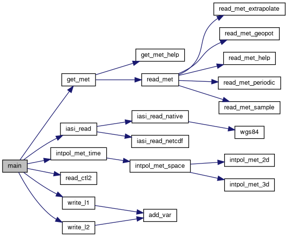
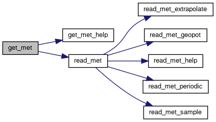
| void | get_met (ctl2_t *ctl2, char *metbase, double t, met_t *met0, met_t *met1) |
| Get meteorological data for given timestep. More... | |
| void | get_met_help (double t, int direct, char *metbase, double dt_met, char *filename) |
| Get meteorological data for timestep. More... | |
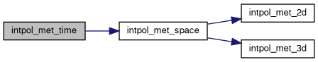
| void | intpol_met_2d (double array[EX][EY], int ix, int iy, double wx, double wy, double *var) |
| Linear interpolation of 2-D meteorological data. More... | |
| void | intpol_met_3d (float array[EX][EY][EP], int ip, int ix, int iy, double wp, double wx, double wy, double *var) |
| Linear interpolation of 3-D meteorological data. More... | |
| void | intpol_met_space (met_t *met, double p, double lon, double lat, double *ps, double *pt, double *z, double *t, double *u, double *v, double *w, double *pv, double *h2o, double *o3) |
| Spatial interpolation of meteorological data. More... | |
| void | intpol_met_time (met_t *met0, met_t *met1, double ts, double p, double lon, double lat, double *ps, double *pt, double *z, double *t, double *u, double *v, double *w, double *pv, double *h2o, double *o3) |
| Temporal interpolation of meteorological data. More... | |
| void | read_ctl2 (int argc, char *argv[], ctl2_t *ctl2) |
| Read control parameters. More... | |
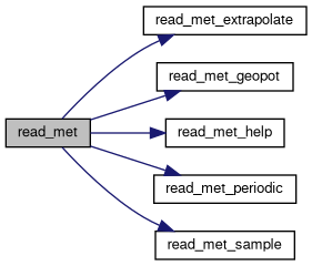
| void | read_met (ctl2_t *ctl2, char *filename, met_t *met) |
| Read meteorological data file. More... | |
| void | read_met_extrapolate (met_t *met) |
| Extrapolate meteorological data at lower boundary. More... | |
| void | read_met_geopot (ctl2_t *ctl2, met_t *met) |
| Calculate geopotential heights. More... | |
| void | read_met_help (int ncid, char *varname, char *varname2, met_t *met, float dest[EX][EY][EP], float scl) |
| Read and convert variable from meteorological data file. More... | |
| void | read_met_periodic (met_t *met) |
| Create meteorological data with periodic boundary conditions. More... | |
| void | read_met_sample (ctl2_t *ctl2, met_t *met) |
| Downsampling of meteorological data. More... | |
| int | main (int argc, char *argv[]) |
Variables | |
| int | iasi_chan [L1_NCHAN] |
| List of IASI channels (don't change). More... | |
Detailed Description
Extract radiance data for retrievals.
Definition in file extract.c.
Macro Definition Documentation
◆ EP
| #define EP 72 |
◆ EX
| #define EX 362 |
◆ EY
| #define EY 182 |
Function Documentation
◆ get_met()
Get meteorological data for given timestep.
Definition at line 356 of file extract.c.
◆ get_met_help()
| void get_met_help | ( | double | t, |
| int | direct, | ||
| char * | metbase, | ||
| double | dt_met, | ||
| char * | filename | ||
| ) |
Get meteorological data for timestep.
Definition at line 388 of file extract.c.
◆ intpol_met_2d()
| void intpol_met_2d | ( | double | array[EX][EY], |
| int | ix, | ||
| int | iy, | ||
| double | wx, | ||
| double | wy, | ||
| double * | var | ||
| ) |
Linear interpolation of 2-D meteorological data.
Definition at line 414 of file extract.c.
◆ intpol_met_3d()
| void intpol_met_3d | ( | float | array[EX][EY][EP], |
| int | ip, | ||
| int | ix, | ||
| int | iy, | ||
| double | wp, | ||
| double | wx, | ||
| double | wy, | ||
| double * | var | ||
| ) |
Linear interpolation of 3-D meteorological data.
Definition at line 438 of file extract.c.
◆ intpol_met_space()
| void intpol_met_space | ( | met_t * | met, |
| double | p, | ||
| double | lon, | ||
| double | lat, | ||
| double * | ps, | ||
| double * | pt, | ||
| double * | z, | ||
| double * | t, | ||
| double * | u, | ||
| double * | v, | ||
| double * | w, | ||
| double * | pv, | ||
| double * | h2o, | ||
| double * | o3 | ||
| ) |
Spatial interpolation of meteorological data.
Definition at line 468 of file extract.c.

◆ intpol_met_time()
| void intpol_met_time | ( | met_t * | met0, |
| met_t * | met1, | ||
| double | ts, | ||
| double | p, | ||
| double | lon, | ||
| double | lat, | ||
| double * | ps, | ||
| double * | pt, | ||
| double * | z, | ||
| double * | t, | ||
| double * | u, | ||
| double * | v, | ||
| double * | w, | ||
| double * | pv, | ||
| double * | h2o, | ||
| double * | o3 | ||
| ) |
Temporal interpolation of meteorological data.
Definition at line 527 of file extract.c.
◆ read_ctl2()
| void read_ctl2 | ( | int | argc, |
| char * | argv[], | ||
| ctl2_t * | ctl2 | ||
| ) |
◆ read_met()
Read meteorological data file.
Definition at line 616 of file extract.c.
◆ read_met_extrapolate()
| void read_met_extrapolate | ( | met_t * | met | ) |
Extrapolate meteorological data at lower boundary.
Definition at line 734 of file extract.c.
◆ read_met_geopot()
Calculate geopotential heights.
Definition at line 765 of file extract.c.
◆ read_met_help()
| void read_met_help | ( | int | ncid, |
| char * | varname, | ||
| char * | varname2, | ||
| met_t * | met, | ||
| float | dest[EX][EY][EP], | ||
| float | scl | ||
| ) |
Read and convert variable from meteorological data file.
Definition at line 908 of file extract.c.
◆ read_met_periodic()
| void read_met_periodic | ( | met_t * | met | ) |
Create meteorological data with periodic boundary conditions.
Definition at line 942 of file extract.c.
◆ read_met_sample()
Downsampling of meteorological data.
Definition at line 977 of file extract.c.
◆ main()
| int main | ( | int | argc, |
| char * | argv[] | ||
| ) |
Definition at line 263 of file extract.c.